- Research
- Open access
- Published:
Morphometric analysis for prioritizing sub-watersheds of Murredu River basin, Telangana State, India, using a geographical information system
Journal of Engineering and Applied Science volume 69, Article number: 44 (2022)
Abstract
The Murredu watershed in Telangana State was chosen for the morphometric and land use/land cover (LULC) analysis in this current study. Geographical information system (GIS) and remote sensing (RS) techniques can estimate the morphometric features and LULC analysis of a catchment. A total of fourteen sub-watersheds (SWs) were created from the watershed (SW 1 to SW 14), and sub-watersheds were prioritized based on morphometric and LULC features. Evaluation of various morphometric characteristics such as linear aspects, relief aspects, and aerial aspects has been carried out for every sub-watershed to prefer ranking. Four parameters were utilized for the LULC analysis to rank and prioritize sub-watersheds. The sub-watersheds were categorized into three groups as low, medium, and high, for soil and water conservation priority based on morphometric and LULC analysis. Using morphometric analysis, higher priorities have been assigned to SW 12 and SW 1, while using LULC analysis, higher priorities have been assigned to SW 9 and SW 11. SW 10 and SW 13 are the most common sub-watersheds that fall within the same priority while using morphometric and LULC analysis. The coefficient of regression results reveals that stream length and stream order, and also stream number and stream order, have a strong association. The deployment of soil and water conservation measures may be conducted in the high-priority sub-watersheds.
Introduction
Morphometric characteristics are a mathematical and quantitative study of the Earth’s surface arrangement, as well as the shape and magnitude of its landforms [3, 10, 34]. A watershed is a section of land where rainwater contributes to a common location [11]. The study of watersheds is crucial for preventing soil erosion, conserving water, and ensuring long-term growth. Techniques like geographical information system (GIS) and remote sensing are powerful tools for analyzing the river basin’s hydraulic process [57].
The size, drainage, shape, and land use pattern of a watershed determine its classification. The many forms of watersheds are mini-watersheds (one to hundred hectares), micro-watersheds (hundred to thousand hectares), milli-watersheds (thousand to ten thousand hectares), sub-watersheds (ten thousand to fifty thousand hectares), and macro-watersheds (greater than fifty thousand hectares). Morphometric characteristics are a helpful process for analyzing watersheds as it shows the relationship among many features of a catchment like a stream order, stream length, etc. Watershed protection has drawn attention towards the safety of natural resources such as soil and water [14].
Various scientists have used traditional methods to analyze various watershed characteristics [13, 16,17,18, 45, 50, 52,53,54], and nowadays, remote sensing and GIS tools have been widely used for watershed analysis [2, 7, 4,5,6, 21, 32, 36, 37, 41, 43, 44, 47, 49, 51, 58]. Morphometric characteristics provide a quantitative catchment report, which is valuable in studies like watershed prioritization, hydrologic modeling, natural resource conservation, etc. [49].
Extracting drainage features from the shuttle radar topography mission (SRTM) digital elevation model (DEM) has become a more popular, accurate, faster, and cost-effective way of conducting catchment studies [22, 31]. Morphometric analysis is a quantitative catchment analysis that reveals the drainage features and development of soil erosion, surface runoff, groundwater infiltration capacity, groundwater potential, etc. [42].
A systematic analysis is essential for the configuration of a catchment, and its stream courses involve relief aspects, linear aspects, and aerial or shape aspects of the catchment [54]. Linear aspects involve the stream length, the number of streams, the bifurcation ratio, the mean stream length ratio, the stream frequency, the stream length ratio, the stream density, the drainage texture, the drainage intensity, the length of the overland flow, and the RHO coefficient. Relief features contain watershed relief, relief ratio, relief relative, ruggedness number, maximum elevation, and minimum elevation. Also, the areal features consist of circulation ratio, watershed area, perimeter, form factor ratio, basin length, elongation ratio, lemniscate ratio, and compactness coefficient [54].
According to scientific studies, morphometric features of a river basin play a significant role in prioritizing sub-watersheds [24]. Sediments, nutrients, and pollutants will be deposited and collected by the water flowing into and out of the basin [35]. They can have a significant impact on the river basin’s onsite and offsite ecosystem. As a result, studying the drainage basin process has the potential to help for a better understanding of how water moves through the hydrologic cycle. Implementing watershed management is crucial for achieving sustainable land and water resource use, as well as mitigating increasing pollutants’ impacts [18, 40, 38]. For the present study, the most relevant quantitative morphometric characteristics have been chosen and applied. Morphometric characteristics can be divided into three categories such as linear, relief, and areal aspects. These have been utilized to prioritize more susceptible sub-watersheds since they have a direct or indirect relationship with peak flow, runoff, and soil erosion hazards [33, 18, 48, 46, 41].
The status of the catchment’s land use/land cover (LULC) is another crucial factor to consider when prioritizing sub-watersheds [18, 19, 39]. The most influential factor and indicator of environmental degradation, including a catchment, is LULC changes. Several researchers have explored and used LULC analysis in catchment prioritizing [25, 55]. Increased slope gradient irregularly enhanced soil erosion rates under various LULC scenarios, which were determined to be greatest at a particular critical degree of slope [59]. Changes in the catchment’s LULC have been recognized as the principal cause of environmental change, resulting in accelerated soil erosion, and are primarily anthropogenic [25]. RS and GIS techniques can represent various LULC categories through classification procedures [1, 9, 12, 15, 20, 23, 26, 29, 56]. RS and GIS techniques have been used in catchment prioritizing [28], which is a basic prerequisite for planners and policymakers to design management schemes that consider the immensity of the catchment area [19].
The objectives of the current study are to prioritize sub-watersheds depending on the morphometric characteristics of each sub-watersheds and also to prioritize sub-watersheds using LULC analysis of each sub-watersheds. Also, the study aims to locate the most common sub-watersheds that fall within the same priority by utilizing both morphometric and LULC analyses.
Study area
Murredu catchment is located in Telangana State. Murredu River is the sub-tributary of the Godavari River, as shown in Fig. 1. Murredu watershed is located between longitudes 80° 20′ 0′′ and 80° 50′ 0′′ East and latitudes 17° 10′ 0′′ and 17° 50′ 0′′ North. It has a total area of 1593.33 km2. The hottest months of the year are usually March to June. The watershed’s rainy season is from July to September. In November, the weather turns cool and stays that way until February. The monsoon arrives in June and lasts until September. The Murredu River basin’s altitude ranges from 57 to 784 m above sea level, according to the SRTM digital elevation model.
Geology
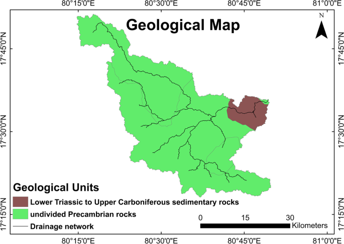
According to the World Geologic Maps of the United States Geological Survey (USGS), the study area has two types of significant rocks. Lower Triassic to Upper Carboniferous and undivided Precambrian are the geological age of two rocks. Sedimentary (Lower Triassic to Upper Carboniferous) and metamorphic rocks (undivided Precambrian) are the type of rocks that were observed in the research area. The undivided Precambrian-Metamorphic Rock occupies the majority of the current study’s area. The drainage pattern of the catchment is dendritic to sub-dendritic. The geological and drainage network of the study area is shown in Fig. 2.
Methods
The SRTM DEM was used for the watershed delineation in this current study. It can be downloaded from USGS Earth Explorer. DEM has a resolution of 30 m. The quantitative morphometric characteristics were performed to examine fourteen sub-watersheds of the Murredu catchment. Table 1 shows the data that was used in this research.
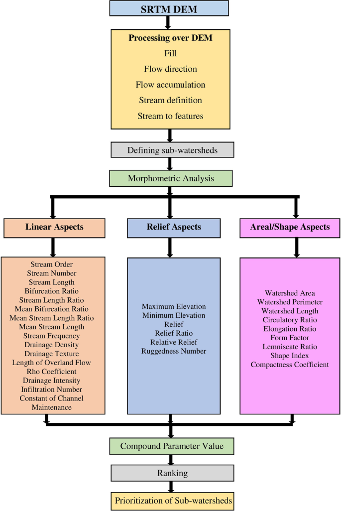
Figure 3 shows the processing of DEM, including fill, flow direction, flow accumulation, stream definition, stream to features, etc. Using ArcGIS 10.4.1 software, sub-watersheds (SW 1 to SW 14) are categorized based on the length of the stream, stream order, stream number, etc. Three groups of morphometric features were studied and categorized; they were linear, relief aspect, and aerial aspect. These features are determined using various empirical methods shown in Table 2. Linear parameters of the Murredu river basin (SW 1 to SW 14) were calculated and presented in Table 3. After getting all the morphometric values, the next step is to find the rank of individual parameters in each sub-watershed. The sub-watershed having the maximum value in the relief and linear characteristics has been ranked as first, while the second maximum value has been ranked as second, the third maximum value has been ranked as third, and so on. The sub-watershed having the minimum value in the areal or shape characteristics has been ranked as first, while the second minimum value has been ranked as second, the third minimum value has been ranked as third, and so on. After getting all ranks for individual parameters in each sub-watershed, the next step is to find the compound parameter value for each sub-watershed. To arrive at the compound parameter value, all the ranks in SW1 are added together and divided by the number of characteristics (the present study area consists of 20 characteristics) and repeat the procedure for other sub-watersheds. Following the calculation of compound values, the sub-watersheds were categorized into three classes high, medium, and low. The high priority has been given to the sub-watersheds with the very low compound value, denoted by the number 1 (high). The medium priority has been given to the sub-watershed with the next low compound parameter value, denoted by the number 2 (medium). The low priority has been given to the sub-watershed with the lowest compound parameter value, denoted by the number 3 (low). The high priority signifies the sub-watershed having the highest risk of runoff, peak flow, and soil erosion [18, 33].
Results and discussion
The quantitative morphometric measurements give information on the catchment’s hydrological features. There are fourteen sub-watersheds in the Murredu catchment. By examining multiple criteria like the basin’s linear aspect, aerial aspect, and relief aspect, the morphometric analysis was utilized to prioritize sub-watersheds (Murredu). The details of various parameters are discussed below.
Basic parameters of river basin
Area of the watershed (A)
The area of the watershed can directly reflect the overall volume of water. It is one of the important parameters because a watershed’s overall area is projected into the horizontal plane. It is denoted by “A.” The overall area of the watershed is 1593.33 km2. In the present study, the largest and smallest sub-watershed areas are 230.95 km2 (SW 8) and 25.79 km2 (SW 2), respectively.
The perimeter of a watershed (P)
Watershed’s outer boundary that encloses its area is defined as the watershed perimeter [21] and is designated by P. The total perimeter of the watershed is 314 km. Out of the fourteen Murredu basins, the largest and smallest sub-watershed perimeters are 164.32 km (SW 8) and 45.46 km (SW 9), respectively.
Watershed length (Lb)
The major dimension among the essential parameters of the major drainage channel is the watershed length [33]. It is denoted by Lb. In the current research, the longest length of the sub-watersheds is at SW 8 (and is 28.87 km), while the shortest is at SW 2 (8.31 km).
Relief (Bh)
Catchment relief is described as the elevation variation between the maximum value and outlet value on the perimeter of the catchment and is denoted by Bh [52]. In this current study, SW 13 has the maximum relief (0.66), and SW 9 has the minimum relief (0.13).
Stream order (U)
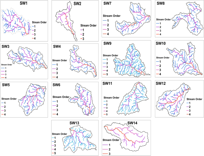
According to Strahler [54], the order of stream is termed as the calculation of the position of a stream in the hierarchy of streams. The smallest finger type, as well as any unbranched tributaries, is termed first stream order. Two first stream orders are combined to generate a second stream order. Following that, the second stream order combines the third, and so on. The letter U is used to represent stream order. Figure 4 depicts the representation of each sub-watershed and its drainage network. The Murredu catchment consists of fourteen sub-watersheds, in that 5th order for SW 9, SW11, and SW13; 4th order for SW 1, SW 3, SW 4, SW 5, SW 6, SW 7, S.W 8, SW 10, and SW 12; and 3rd order for SW 2 and SW 14. The catchment has a dendritic to sub-dendritic drainage structure.
Stream number (Nu)
In a given catchment, the number of streams is defined as the number of streams in each sequence of that catchment [17] and is denoted by the symbol Nu. SW 9 (256) and SW 2 (20), respectively, have the highest and lowest stream numbers in this study.
Stream length (Lu)
Stream length is defined as the mean length of the stream of each of the dissimilar orders in a catchment. As a result, the length of the stream is greater in a first-order stream, and also it increases as stream order increases [17]. It is designated by Lu. In the present research, the lengths of the largest and smallest of the stream are SW 13 (160 km) and SW (28 km), respectively.
Linear aspects
Bifurcation ratio (Rb)
According to Schumm [45], the bifurcation ratio is termed as the proportion of the number of streams of any given order to the number of streams of the next higher order. It was indicated by Rb. In the current study, SW 9 (16) has the maximum bifurcation ratio, and SW 2 has the minimum (8.33).
Mean stream length (Lsm)
It is defined as the ratio of the length of the stream to the number of streams [17] and is denoted by Lsm. In the current study, the maximum (20.97) and minimum (3.72) mean stream lengths are SW 12 and SW 9, respectively.
Stream length ratio (Rl)
It is defined as the ratio of the given order’s average stream length to the next smaller order’s mean stream length [17]. Rl is the symbol for it. SW 9 (3.05) and SW 2 (1.5) had the highest and lowest stream length ratio values, respectively, in the current study.
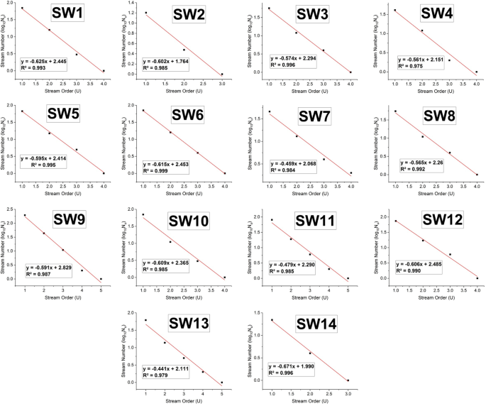
According to Horton [17], the stream length and number of unique orders in a drainage basin are linked by two fundamental rules. The foremost is the law of stream numbers that describes the link between the given order’s stream number and its stream order in terms of an inverted geometric series with the bifurcation ratio as the base. Figure 5 shows a strong correlation between stream order and stream number with better coefficients of determination ranging from SW 4 (0.975) to SW 6 (0.999).
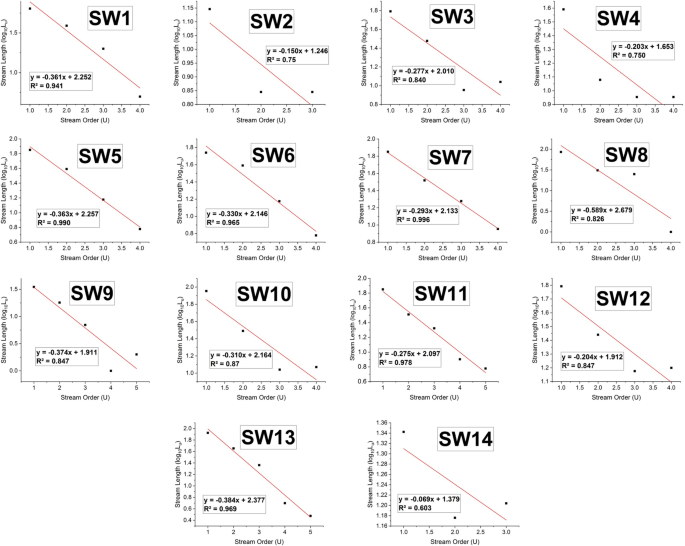
The second is the law of stream length, which is the mean length of a particular order in terms of stream order, the average length of first-order streams, and stream length ratio. This rule is expressed as a direct geometric series. Figure 6 shows a strong correlation between stream order and stream length with coefficients of determination ranging from SW 14 (0.603) to SW 7 (0.996).
Mean bifurcation ratio
Strahler [53] utilized a weighted average ratio of bifurcation generated by multiplying the ratio of bifurcation for every consecutive set of patterns by the overall number of streams occupied in the ratio and taking the average of the combination of these results to arrive at a more representative bifurcation number. SW 1 has the highest value, whereas SW 13 has the lowest value in this study.
Stream frequency (Fs)
Stream frequency is defined as the number of stream segments of all orders per unit catchment area, according to Schumm [45]. It is denoted by Fs. In the current study, the higher stream frequency is at SW 9 and the lower stream frequency is at SW 8.
Drainage density (Dd)
According to Schumm [45], drainage density is defined as the proportion of the overall length of the stream segments of all orders to the catchment area projected on the horizontal surface. It is indicated by Dd. In this study, drainage density is higher at SW 9 and lower at SW 8.
Drainage texture (Dt)
It is defined as the total number of streams per perimeter of the catchment, according to Schumm [45], and is denoted by the symbol Dt. In the current study, drainage texture is maximum at SW 9 and is minimum at SW 2.
Length of the overland flow (Lo)
The highest value of the length of the overland flow indicates greater surface runoff and the lowest value of the length of the overland flow indicates shorter surface runoff, according to Schumm [45]. It is denoted by Lo. The length of the overland flow is higher at SW 8 and lower at SW 9.
Drainage intensity (Di)
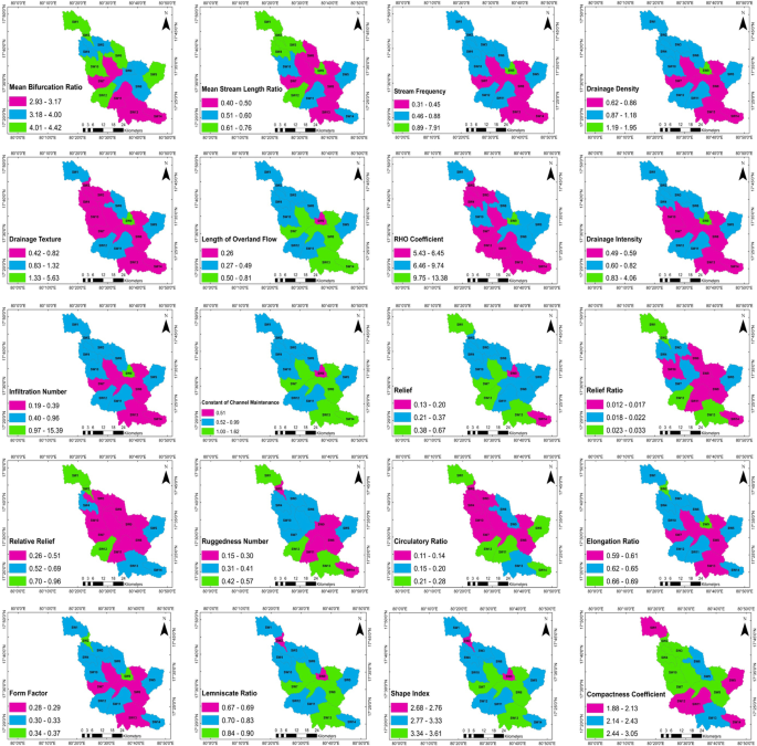
According to Faniren [13], drainage intensity is defined as the ratio of stream frequency to drainage density. It is denoted by Di. In this current study, the drainage intensity is higher and lower at SW 9 and SW 7, respectively, and shown in Fig. 7.
RHO coefficient (ρ)
RHO coefficient is a proportion between the stream length ratio and the bifurcation ratio, according to Horton [17]. It is designated by ρ. In this current study, the RHO coefficient is higher and lower at SW 9 and SW 14, respectively.
Infiltration number (If)
It is defined as the combination of stream frequency and drainage density, according to Faniran [13], and is denoted by If. In the current study, SW 9 has a higher infiltration number and SW 8 has a lower infiltration number.
Constant of channel maintenance (ccm)
This property defines the number of units of catchment surface needed to support one unit of route length. In other terms, it is the number of square kilometers of catchment surface area required to support one linear kilometer of stream segment. It was first proposed by Schumm in 1956 [45], who defined the channel maintenance constant as the reverse of drainage density. In the current study, SW 8 has a higher constant of channel maintenance and SW 9 has a lower constant of channel maintenance.
Areal aspect
Circulatory ratio (Rc)
According to Miller [30], it is termed as the proportion of the area of a catchment to the area of the circle with an equal circumference as the catchment’s perimeter. It is indicated as Rc. Its ratio indicates the shape of the catchment. In the current study, SW 5 has a higher circulatory ratio and SW 8 has a lower circulatory ratio.
Elongation ratio (Re)
It is defined as the proportion of the diameter of a circle covering the equal area as the catchment to the minimum length of the catchment, as per Schumm [45]. It is denoted by Re. In this current study, SW 2 has a higher elongation ratio and SW 8 has a lower elongation ratio.
Form factor (Ff)
Form factor is defined as the proportion of catchment area to the square of catchment length, according to Horton [17]. It is denoted by Ff. In this present study, SW 2 has a higher form factor and SW 8 has a lower form factor.
Lemniscate ratio (K)
It is used to calculate the catchment’s slope [8]. It is denoted by K. In this present study, SW 8 has a higher lemniscate ratio and SW 2 has a lower lemniscate ratio.
Shape index (Sb)
The shape index is the reciprocal of the form factor. It was first proposed by Horton [16]. It is denoted by the symbol Sb. In this present study, SW 8 has a higher shape index and SW 2 has a lower shape index.
Compactness coefficient (Cc)
According to Horton [17], the compactness coefficient is termed as the proportion of the catchment’s perimeter to the circumference of an equivalent circular area and is indicated as Cc. In this present study, SW 8 has a higher compactness coefficient and SW 5 has a lower compactness coefficient.
Relief aspect
Relief ratio (Rh)
According to Schumm [45], the relief ratio is termed as the proportion of the maximum catchment relief (Bh) to the minimum catchment length which is parallel to the primary catchment line and is denoted by Rh. In this current study, the higher value of the relief ratio is at SW 2 and the lower value of the relief ratio is at SW 13.
Relative relief (Rhp)
The perimeter and watershed are used to determine relative relief [27]. Rhp is the symbol for it. SW 2 has the higher value, whereas SW 8 has the lower value in this study.
Ruggedness ratio (Rn)
According to Strahler [53], the ruggedness ratio is used to measure the surface unevenness or roughness. It is the combination of drainage density and maximum catchment relief and is denoted by Rn. In this study, the higher value and lower value have been identified at SW 13 and SW 14, respectively.
Hypsometric analysis
The relative proportion of the catchment areas below or above a specific height is represented by the hypsometric curve for a catchment. The hypsometric integral is defined as the area below the hypsometric curve [52, 45], and it has been used to determine the stage of development of a catchment, along with the hypsometric curve. The catchment is split into three phases such as old, mature, and young. The value of the hypsometric integral in the old stage is less than 0.3, the mature stage is between 0.3 and 0.6, and the youthful stage is greater than 0.6. The hypsometric integral is shown in Table 4.
Morphometric sub-watershed prioritization and ranking
For this analysis, the most relevant quantitative morphometric characteristics are chosen and applied. Morphometric characteristics can be divided into three categories (linear features, relief features, and areal features). These have been utilized to prioritize more susceptible sub-watersheds since they have a direct or indirect relationship with peak flow, runoff, and risk of soil erosion [17, 18, 48, 46].
Soil erosion is directly relevant to the linear and relief characteristics such as mean bifurcation ratio, drainage density, stream frequency, drainage texture, relief, ruggedness number, and so on [18, 33]. The maximum value of linear and relief characteristics in a catchment indicates the most erodible soil. Consequently, the sub-watershed with the maximum value in the relief and linear characteristics is ranked first, while the second maximum value is ranked as second, the third maximum value is ranked as third, and so on.
The areal characteristics such as circularity ratio, shape index, compactness coefficient, elongation ratio, form factor, and lemniscate ratio have an indirect relationship with soil erosion [18, 33]. The most erodible soil in a catchment is the soil with the minimum areal characteristic value. Hence, sub-watershed having the lowest areal characteristics values will be ranked first, the second lowest areal characteristic values will be ranked as second, the third lowest areal characteristic values will be ranked as third, and so on.
For linear and relief parameters, the maximum value is given a ranking of 1, and the next maximum value is given a ranking of 2, and so on. In the case of areal parameters, the minimum value was given a ranking of 1, followed by the next minimum value is given a ranking of 2, and so on.
After assigning a ranking based on each parameter, the ranking values for all fourteen sub-watersheds were averaged to arrive at a compound parameter value. Table 5 shows the results of ranking for all fourteen sub-watersheds. Sub-watershed 1 has a compound value of 5.75 if all the ranks in SW1 are added together and divided by 20 characteristics. The procedure has been repeated for other sub-watersheds (from SW 2 to SW 14) and presented in Table 6.
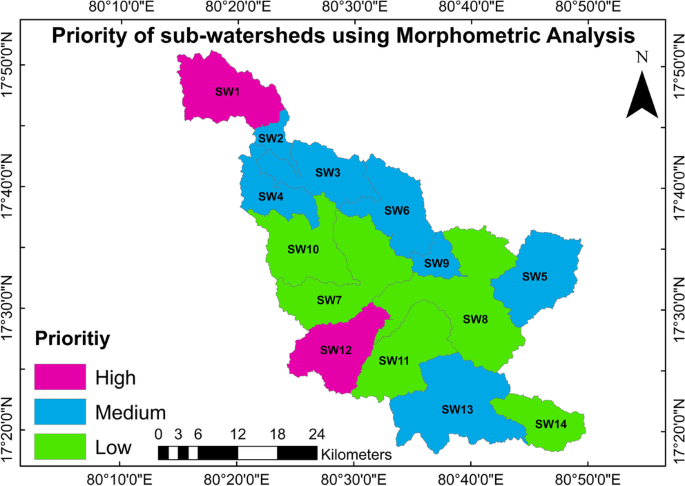
Following the calculation of compound values, the sub-watersheds were categorized into three groups, high (≥ 5.05 to < 6.5), medium (≥ 6.5 to < 8), and low (≥ 8 to < 9.5). The sub-watershed with the minimum compound value represents as rank 1 category, SW having the next minimum compound value represents as rank 2 category, and so on. The sub-watersheds with the compound value in the range of ≥ 5.05 to < 6.5 have been specified as high priority. The sub-watershed with the compound value in the range of ≥ 6.5 to < 8 has been chosen as a medium priority. The sub-watersheds with the compound value in the range of ≥ 8 to < 9.5 have been specified as a slow priority. Among 14 sub-watersheds, SW 12 and SW 1 are falling within high priority; SW 2, SW 3, SW 4, SW 5, SW 6, SW 9, and SW 13 fall within a medium priority; and SW 7, SW 8, SW 10, SW 11, and SW 14 fall within a low priority. This means that the sub-watersheds with the highest priority have the greatest danger of runoff, peak flow, and soil erosion risk [18, 33].
The final priority map of sub-watersheds in the Murredu catchment is shown in Fig. 8. SW 12 and SW 1 are the most vulnerable sub-watersheds to land degradation, and they are more vulnerable to soil erosion and runoff. As a result, the findings will help in better planning and the management of the Murredu catchment.
Land Use/Land Cover (LULC) analysis
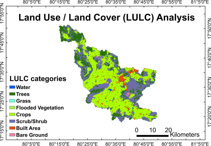
Prioritization of LULC of sub-watersheds was based on LULC data of the year 2020 from Sentinel-2 imagery. LULC has a resolution of 10 m. LULC categories include eight primary classes such as grass, flooded vegetation, water, trees, crops, scrub/shrub, built-up area, and bare ground. Figure 9 depicts the LULC map of the research area. Table 7 shows the details of the various LULC categories. The following classes are the LULC criteria that were considered for prioritizing sub-watersheds.
Trees
SW 14 has the highest percentage of land with trees (55.48%), while SW 7 has the lowest percentage of trees (5.40%). Sub-watersheds with a smaller percentage of trees have been given a high rank, while those with a higher percentage of trees have been given a low rank.
Crops
SW 11 has the highest percentage of land with crops (79.97%), while SW 1 has the lowest percentage of crops (18.22%). Sub-watersheds with a small percentage of crops were given a high rank, while those with a high percentage of crops were given a low rank.
Scrub/shrub
SW 5 has the highest percentage of scrub/shrub (41.53%), while SW 11 has the lowest percentage of scrub (7.63%). Sub-watersheds with a lower percentage of scrub/shrub have a high rank, whereas those with a larger percentage of scrub/shrub have a low rank.
Built-up area
SW 9 has the highest percentage of land with the built-up area (25.80%), while SW 4 has the lowest percentage of built-up area (0.31%). Sub-watersheds with a larger percentage of the constructed area have a low rank, while sub-watersheds with a smaller percentage of the built-up area have a high rank.
For the built-up area parameter, the maximum value was given a ranking of 1, and the next maximum value was given a ranking of 2, and so on. In the case of trees, crops, and scrub/shrub parameters, the minimum value was given a ranking of 1, followed by the next minimum value is given a ranking of 2, and so on.
The compound parameter method of averaging values was applied for sub-watershed prioritization. Table 8 shows the results of the ranking of all fourteen sub-watersheds. All the ranks in SW1 are added together and divided by four characteristics, and then the compound parameter has been computed as 8. The procedure has been repeated for the remaining sub-watersheds from SW 2 to sw14, as shown in Table 9.
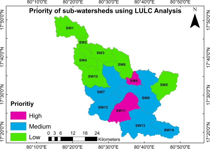
Following the calculation of compound values, the sub-watersheds were categorized into three groups, high (≥ 4 to < 6), medium (≥ 6 to < 8), and low (≥ 8 to < 10). The sub-watershed with the minimum compound value represents as rank 1 category, SW having the next minimum compound value represents as rank 2 category, and so on. The sub-watersheds with the compound value in the range of ≥ 4 to < 6 have been specified as a high priority. The sub-watershed with the compound value in the range of ≥ 6 to < 8 has been chosen as a medium priority. The sub-watersheds with the compound value in the range of ≥ 8 to < 10 have been specified as low priority. Among four sub-watersheds, SW 9 and SW11 are falling within a high priority; SW 7, SW 8, SW 12, SW 13, and SW 14 fall within a medium priority; and SW 1, SW 2, SW 3, SW 4, SW 5, SW 6, and SW 10 fall within a low priority. Figure 10 shows the priority of sub-watersheds based on LULC analysis.
The quantitative analysis of morphometric factors will be used in the development of catchment, river basin prioritizing for soil conservation, and also for water conservation. Morphometric descriptors are simple techniques for defining catchment processes that can be used to compare catchment characteristics and for a better understanding of the geological history of the catchment. According to the data, SW 9 and SW11 have the highest priority, and SW 1, SW 2, SW 3, SW 4, SW 5, SW 6, and SW 10 have the lowest priority among sub-watersheds. The results of morphometric and LULC analysis were compared to determine the most common sub-watersheds associated with each priority. According to morphometric study and LULC analysis, two sub-watersheds, SW 10 and SW 13, are the common sub-watersheds that fall within a low and medium priority, respectively.
Conclusions
GIS and remote sensing approaches have been used for morphometric and LULC research over the Murredu catchment area. Twenty parameters of morphometric and four parameters of LULC have been calculated and scientifically analyzed in this current study. The results of morphometric analysis-based prioritization showed that the SW 12 and SW 1 sub-watersheds are of high priority. The results of the LULC analysis-based prioritizing showed that the SW 9 and SW11 sub-watersheds are of high priority. Comparing morphometric and LULC analysis, the common sub-watersheds falling within the same priority are SW 10 and SW 13. The deployment of soil and water conservation measures may be conducted in the high-priority sub-watersheds. As a result, effective land and water management strategies should be planned for each sub-watershed based on their sensitivity rankings.
Availability of data and materials
The datasets generated during and/or analyzed during the current study are available from the corresponding author on reasonable request.
Abbreviations
- LULC:
-
Land use/land cover
- SWs:
-
Sub-watersheds
- GIS:
-
Geographical information system
- RS:
-
Remote sensing
- SRTM:
-
Shuttle radar topography mission
- DEM:
-
Digital elevation model
- USGS:
-
United States Geological Survey
- ESRI:
-
Environmental Systems Research Institute
- U :
-
Stream order
- L u :
-
Stream length
- N u :
-
Stream number
- R l :
-
Stream length ratio
- R b :
-
Bifurcation ratio
- R bm :
-
Mean bifurcation ratio
- L sm :
-
Mean stream length
- R lm :
-
Mean stream length ratio
- F s :
-
Stream frequency
- D d :
-
Drainage density
- D t :
-
Drainage texture
- L o :
-
Length of overland flow
- ρ :
-
RHO coefficient
- D i :
-
Drainage intensity
- I f :
-
Infiltration number
- C cm :
-
Constant of channel maintenance
- H :
-
Maximum elevation
- h :
-
Minimum elevation
- B h :
-
Relief
- R h :
-
Relief ratio
- R hp :
-
Relative relief
- R n :
-
Ruggedness number
- A :
-
Area of watershed
- P :
-
Perimeter of watershed
- L b :
-
Basin length
- R c :
-
Circulatory ratio
- R e :
-
Elongation ratio
- F f :
-
Form factor
- K :
-
Lemniscate ratio
- S b :
-
Shape index
- C c :
-
Compactness coefficient
- x :
-
Sum of rankings
- y :
-
Total number of parameters
- x/y :
-
Compound parameter
References
AbdelRahman MAE, Natarajan A, Hegde R, Prakash SS (2019) Assessment of land degradation using comprehensive geostatistical approach and remote sensing data in GIS-model builder. Egypt J Remote Sens Space Sci 22:323–334
Abdeta GC, Tesemma AB, Tura AL, Atlabachew GH (2020) Morphometric analysis for prioritizing sub-watersheds and management planning and practices in Gidabo Basin, Southern Rift Valley of Ethiopia. Appl Water Sci 10:158
Agarwal CS (1998) Study of drainage pattern through aerial data in Naugarh area of Varanasi district, U.P. J Indian Soc Remote Sensing 26:169–175. https://doi.org/10.1007/BF02990795
Aravinda PT, Balakrishna HB (2013) Morphometric analysis of Vrishabhavathi watershed using remote sensing and GIS. Int J Res Engin Techn 2(8):514–522 eISSN: 2319-1163 | pISSN: 2321-7308
Balazs B, Biro T, Dyke G, Singh SK, Szabo S (2018) Extracting water-related features using reflectance data and principal component analysis of Landsat images. Hydrol Sci J 63(2):269–284. https://doi.org/10.1080/02626667.2018.1425802
Bogale A (2021) Morphometric analysis of a drainage basin using geographical information system in GilgelAbay watershed, Lake Tana Basin, upper Blue Nile Basin, Ethiopia. Appl Water Sci. https://doi.org/10.1007/s13201-021-01447-9
Chauhan P, Chauniyal DD, Singh N, Tiwari RK (2016) Quantitative geo-morphometric and land cover-based micro-watershed prioritization in the Tons river basin of the lesser Himalaya. Environ Earth Sci 75:498. https://doi.org/10.1007/s12665-016-5342-x
Chorley RJ, Malm DEG, Pogorzelski HA (1957) A new standard for estimating drainage basin shape. Am J Sci 225:138–141
Choudhari PP, Nigam GK, Singh SK, Thakur S (2018) Morphometric based prioritization of watershed for groundwater potential of Mula river basin, Maharashtra, India. Geol Ecol Landscapes 2(4):256–267. https://doi.org/10.1080/24749508.2018.1452482
Clarke JJ (1966) Morphometry from maps. Essays in geomorphology. Elsevier, New York, pp 235–274
Desta L, Carucci V, Wendem-Ageňehu A, Abebe Y (2005) Community based participatory watershed development: a guideline. Ministry of Agriculture and Rural Development, Addis Ababa, Ethiopia
Elagouz MH, Abou-Shleel SM, Belal AA, El-Mohandes MAO (2020) Detection of land use/cover change in Egyptian Nile Delta using remote sensing. Egypt J Remote Sens Space Sci 23:57–62
Faniran A (1968) The index of drainage intensity: a provisional new drainage factor. Austr J Sci 31(9):326–330
Gumma MK, Birhanu BZ, Mohammed IA, Tabo R, Whitbread AM (2016) Prioritization of watersheds across Mali using remote sensing data and GIS techniques for agricultural development planning. Water 8(6):260
Gupta N, Mathew A, Khandelwal S (2020) Spatio-temporal impact assessment of land use/land cover (LU-LC) change on land surface temperatures over Jaipur city in India. Int J Urban Sustain Dev 12(3):283–299. https://doi.org/10.1080/19463138.2020.1727908
Horton RE (1932) Drainage basin characteristics. Trans Am Geophys Union 13:350–361
Horton RE (1945) Erosional development of streams and their drainage basins; hydro physical approach to quantitative morphology. Bull Geol Soc Am 56:275–370
Javed A, Khanday MY, Ahmed R (2009) Prioritization of sub-watersheds based on morphometric and land use analysis using remote sensing and GIS techniques. J Indian Soc Remote Sensing 37:261
Javed A, Khanday MY, Rais S (2011) Watershed prioritization using morphometric and land use analysis parameters: a remote sensing and GIS based approach. J Geol Soc India 78:63–75
Jazouli AE, Barakat A, Khellouk R, Rais J, Baghdadi ME (2019) Remote sensing and GIS techniques for prediction of land use land cover change effects on soil erosion in the high basin of the Oum Er Rbia River (Morocco). Remote Sensing Appl Soc Environ 13:361–374
Khan I, Bali R, Agarwal KK, Kumar D, Singh SK (2021) Morphometric analysis of Parvati Basin, NW Himalaya: a remote sensing and GIS based approach. J Geol Soc India 97(2):165–172
Maathuis BHP, Wang L (2006) Digital elevation model based hydro-processing. Geocarto Int 21(1):21–26
Magalhaes SFCD, Barboza CADM, Maia MB, Molisani MM (2022) Influence of land cover, catchment morphometry and rainfall on water quality and material transport of headwaters and low order streams of as tropical mountainous watershed. Catena 213:106137
Magesh NS, Jitheshlal KV, Chandrasekar N, Jini KV (2013) Geographical information system based morphometric analysis of Bharathapuzha river basin, Kerala, India. Appl Water Sci 3:467–477
Malik MI, Bhat MS (2014) Integrated approach for prioritizing watersheds for management: a study of Lidder catchment of Kashmir Himalayas. Environ Manag 54:1267–1287
Mathew A, Sarwesh P, Khandelwal S (2022) Investigating the contrast diurnal relationship of land surface temperatures with various surface parameters represent vegetation, soil, water, and urbanization over Ahmedabad city in India. Energy Nexus 5:100044
Melton M (1957) An analysis of the relations among elements of climate, surface properties and geomorphology. Project NR 389- 042, technical report 11, Columbia University, Technical Report, 11, Project NR 389-042.
Meshram SG, Shrama SK (2015) Prioritization of watershed through morphometric parameters: a PCA-based approach. Appl Water Sci 7:1505–1519
Mfwango LH, Kisiki CP, Ayenew T, Mahoo HF (2022) The impact of land use/cover change on surface runoff at Kibungo sub-catchment of Upper Ruvu catchment in Tanzania. Environ Challenges 7:100466
Miller VC (1953) A quantitative geomorphologic study of drainage basin characteristics in the Clinch mountain area, Virginia and Tennessee. Technical report 3, Columbia University, New York, pp 389–402
Moore ID, Grayson RB, Ladson AR (1991) Digital terrain modelling: a review of hydrological, geomorphological, and biological applications. Hydrol Process 5(1):3–30. https://doi.org/10.1002/hyp.3360050103
Narsimlu B, Gosain AK, Chahar BR, Singh SK, Srivastava PK (2015) SWAT model calibration and uncertainty analysis for streamflow prediction in the Kunwari River Basin, India, using sequential uncertainty fitting. Environ Process 2:79–95
Nookaratnam K, Srivastava YK, Venkateswarao V, Amminedu E, Murthy KSR (2005) Check dam positioning by prioritization of micro-watersheds using SYI model and morphometric analysis remote sensing and GIS perspective. J Indian Soc Remote Sens 33(1):25–38
Obi RGE, Maji AK, Gajbhiye KS (2002) GIS for morphometric analysis of drainage basins. GIS India 4(11):9–14
Oyegoke S, Ifeadi C (2008) Relationship between drainage basin area and stream length for River Gongola, Nigeria. Environ Res J 2(1):23–27
Pandey A, Chowdary VM, Mal BC (2004) Morphological analysis and watershed management using GIS. Hydrology J 27(3 & 4):71–84
Perucca LP, Angilieri YE (2010) Morphometric characterization of del Molle Basin applied to the evaluation of flash floods hazard, Iglesia Department, San Juan, Argentina. Quat Int. https://doi.org/10.1016/j.quaint.2010.08.007
Prakash K, Rawat D, Singh S (2019) Morphometric analysis using SRTM and GIS in synergy with depiction: a case study of the Karmanasa River basin, North central India. Appl Water Sci 9:13
Puno GR, Puno RCC (2019) Watershed conservation prioritization using geomorphometric and land use-land cover parameters. Global J Environ Sci Manage 5(3):279–294
Rai PK, Mishra VN, Mohan K (2017) A study of morphometric evaluation of the Son Basin, India using geospatial approach. Remote Sensing Applic 7:9–20
Rais S, Javed A (2014) Drainage characteristics of Manchi Basin, Karauli District, Eastern Rajasthan using remote sensing and GIS techniques. Int J Geomatics Geosci 5(1):285–299
Raj PN, Azeez PA (2012) Morphometric analysis of a tropical medium river system: a case from Bharathapuzha River southern India. Open J Modern Hydrol 2:91–98
Redvan G, Mustafa U (2021) Flood prioritization of basin based on geomorphometric properties using principal component analysis, morphometric analysis and Redvan’s priority methods: a case study of Harshit river basin. J Hydrol. https://doi.org/10.1016/j.jhydrol.2021.127061
Sahu N, Reddy GPO, Kumar N, Nagaraju MSS, Srivastava R, Singh SK (2016) Morphometric analysis in basaltic Terrain of Central India using GIS techniques: a case study. Appl Water Sci. https://doi.org/10.1007/s13201-016-0442-z
Schumm SA (1956) Evaluation of drainage system and slopes in bad lands at Perth Amboy, New Jersey. Geol Soc Am Bull 67(5):597–646
Sharma SK, Gajbhiye S, Tignath S, Patil R (2018) Hypsometric analysis for assessing erosion status of watershed using geographical information system. Hydrol Model 81:263–276
Sharma S, Mahajan AK (2020) GIS-based sub-watershed prioritization through morphometric analysis in the outer Himalayan region of India. Appl Water Sci 10:163. https://doi.org/10.1007/s13201-020-01243-x
Singh P, Gupta A (2014) Singh M (2014) Hydrological inferences from watershed analysis for water resource management using remote sensing and GIS techniques. Egypt J Remote Sens Space Sci 17:111–121
Singh WR, Barman S, Trikey G (2021) Morphometric analysis and watershed prioritization in relation to soil erosion in Dudhnai Watershed. Appl Water Sci. https://doi.org/10.1007/s13201-021-01483-5
Smith KG (1950) Standards for grading texture of erosional topography. Am J Sci 248(655):668. https://doi.org/10.2475/ajs.248.9.655
Sreedevi P, Subrahmanyam K, Ahmed S (2005) The significance of morphometric analysis for obtaining groundwater potential zones in a structurally controlled terrain. Environ Geol 47:412–420
Strahler AN (1952) Hypsometric analysis of erosional topography. Geol Soc Am Bull 63:1117–1142
Strahler AN (1957) Quantitative analysis of watershed geomorphology in drainage basin morphometry. Benchmark papers in geology 41, edited by H.S. Schumn Transact Am Geophys Union 38(6):913–920
Strahler AN (1964) Quantitative geomorphology of drainage basins and channel networks. In: Chow V (ed) Handbook of applied hydrology. McGraw Hill, New York, pp 439–476
Sujatha ER, Selvakumar R, Rajasimman B (2014) Watershed prioritization of Palar sub-watershed based on the morphometric and land use analysis. J Mountain Sci 11(4):906–916
Thakkar AK, Desai VR, Patel A, Potdar MB (2017) Impact assessment of watershed management programmes on land use/land cover dynamics using remote sensing and GIS. Remote Sensing Appl 5:1–15
Waikar M, Nilawar AP (2014) Morphometric analysis of a drainage basin using geographical information system: a case study. Int J Multidisciplin Current Res 2:179–184
Yadav SK, Singh SK, Gupta M, Srivastava PK (2014) Morphometric analysis of Upper Tons basin from Northern Foreland of Peninsular India using CARTOSAT satellite and GIS. Geocarto Int 29(8):895–914
Zhang Z, Sheng L, Yang J, Chen X, Kong L, Wagan B (2015) Effects of land use and slope gradient on soil erosion in a red soil hilly watershed of Southern China. Sustainability 7:14309–14325
Acknowledgements
The authors would like to thank the anonymous reviewers for their instructive comments, which helped to improve this paper. In addition, the authors wish to thank the US Geological Survey (USGS) for making available the satellite data. Finally, the authors also want to thank ESRI for providing land use land cover data.
Funding
No specific funding has to be declared for this work.
Author information
Authors and Affiliations
Contributions
PRS: conceptualization, methodology, software, data curation, and writing—original draft preparation; AM: supervision, visualization, and investigation writing—reviewing and editing. The authors read and approved the final manuscript.
Corresponding author
Ethics declarations
Competing interests
The authors declare that they have no competing interests.
Additional information
Publisher’s Note
Springer Nature remains neutral with regard to jurisdictional claims in published maps and institutional affiliations.
Rights and permissions
Open Access This article is licensed under a Creative Commons Attribution 4.0 International License, which permits use, sharing, adaptation, distribution and reproduction in any medium or format, as long as you give appropriate credit to the original author(s) and the source, provide a link to the Creative Commons licence, and indicate if changes were made. The images or other third party material in this article are included in the article's Creative Commons licence, unless indicated otherwise in a credit line to the material. If material is not included in the article's Creative Commons licence and your intended use is not permitted by statutory regulation or exceeds the permitted use, you will need to obtain permission directly from the copyright holder. To view a copy of this licence, visit http://creativecommons.org/licenses/by/4.0/. The Creative Commons Public Domain Dedication waiver (http://creativecommons.org/publicdomain/zero/1.0/) applies to the data made available in this article, unless otherwise stated in a credit line to the data.
About this article
Cite this article
Shekar, P.R., Mathew, A. Morphometric analysis for prioritizing sub-watersheds of Murredu River basin, Telangana State, India, using a geographical information system. J. Eng. Appl. Sci. 69, 44 (2022). https://doi.org/10.1186/s44147-022-00094-4
Received:
Accepted:
Published:
DOI: https://doi.org/10.1186/s44147-022-00094-4

